
This attraction introduction is compiled from historical materials in the "Zhangjiajie Tour Guide Network" (33519.com · Scenic Spots section). Ticket prices, opening hours, transportation, and contact information mentioned in the text may be outdated. Please refer to the latest official announcements from the scenic area before traveling; some content consists of historical background/cultural introductions and is for reference only.
Zhangjiajie City is located between 28°52′–29°48′ north latitude and 109°40′–111°20′ east longitude. It is an emerging prefecture-level city under Hunan Province in the northwest of the province, currently being developed and constructed, characterized by the development of Zhangjiajie tourism.
The seat of Zhangjiajie City was originally named Dayong. On May 18, 1988, the state approved the establishment of prefecture-level Dayong City; because the name "Dayong" was far less well known than Zhangjiajie, China's first national forest park within its jurisdiction, on April 4, 1994, the State Council approved the renaming of Dayong City to Zhangjiajie City. The city administers two districts, Yongding and Wulingyuan, and two counties, Cili and Sangzhi. In 2008, the total population was 1,639,500, and the total area was 9,563 square kilometers. The city government is located in Yongding District, 390 kilometers from the provincial capital Changsha and 300 kilometers from the Three Gorges of the Yangtze River.
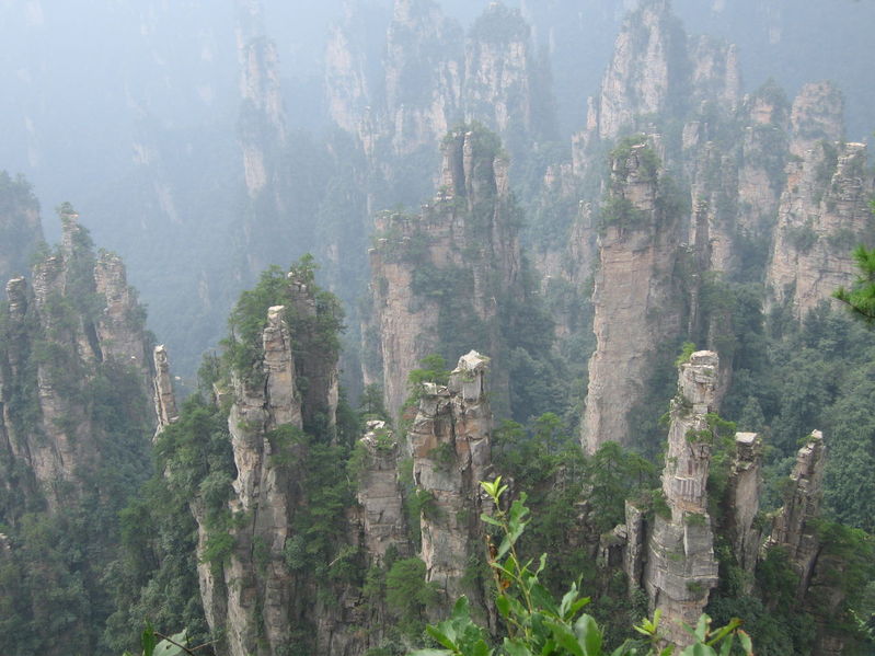
Zhangjiajie is said to have been named after Zhang Liang, the Marquis of Liu of the Han Dynasty, who lived in seclusion here. In the 1950s, the local government established a state-run forestry farm in Zhangjiajie. In the late 1970s, Zhangjiajie's rare quartz sandstone peak forest wonder was discovered by the world and thus developed. On September 25, 1982, the State Planning Commission issued a document designating the area under the forestry farm as "Zhangjiajie Forest Park." Zhangjiajie became China's first national forest park.
Zhangjiajie National Forest Park, together with the two major nature reserves of Suoxiyu and Tianzi Mountain, which are connected as one, forms Wulingyuan, the core scenic area of Zhangjiajie. Wulingyuan is located in the middle section of the Wuling Mountains; the Wuling Mountains stretch across Hunan, Hubei, Guizhou, Sichuan, and other provinces. The Tang poet Wang Wei once wrote: 'Residents all live in Wulingyuan, and beyond worldly things they establish fields and gardens.' In 1984, Hu Yaobang, then General Secretary of the CPC Central Committee, inspected this place and named the three major scenic areas of Zhangjiajie, Suoxiyu, and Tianzi Mountain 'Wulingyuan.' In 1988, when Dayong (now renamed Zhangjiajie) was established as a prefecture-level city, a county-level administrative region of Wulingyuan was specially set up, covering 369 square kilometers.
Wulingyuan has well-developed karst landforms, and its quartz sandstone peak forest and gorge landforms are even more rare in the world. In October 1988, the State Council designated Wulingyuan as a national key scenic and historic area. On December 7, 1992, the World Heritage Committee of UNESCO approved the inclusion of Wulingyuan as a World Natural Heritage site on the World Heritage List. Experts and scholars at home and abroad have praised Wulingyuan as a 'labyrinth of nature' and an incredible 'monument of the Earth.' The Technical Evaluation Report of the International Union for Conservation of Nature and Natural Resources stated: 'In scenic terms, Wulingyuan can be compared with several national forest parks and monuments in the western United States. Wulingyuan possesses undeniable natural beauty. It has magnificent and jagged stone peaks, lush vegetation, and clear lakes and streams.'
In addition to the Wulingyuan core scenic area, Zhangjiajie City also has Badagongshan Nature Reserve in Sangzhi County, Jiutian Cave, the largest cave in Asia, and Hongjiaguan, the hometown of Marshal He Long; Wulei Mountain, a Taoist holy site, and Wanfu Hot Springs in Cili County; as well as Tianmen Mountain Forest Park in Yongding District, where the city government is located, Maoyan River, which has developed rafting tourism projects, the 'Famous Jiangnan Temple' Puguang Zen Temple, Yuhuang Cave Grottoes, and more than 300 other natural and cultural scenic spots. Zhangjiajie City is also a settlement area for ethnic minorities such as the Tujia, Bai, and Miao, who account for 69% of the city's total population. Various folk customs often greatly interest domestic and international tourists and inspire endless reverie. Surrounding Zhangjiajie City are also scenic spots such as Taohuayuan and Mengdong River, and it is also very convenient to go to the Three Gorges and Guilin.
Since its development, Zhangjiajie City has basically formed a transportation network integrating water transport, land routes, and aviation, making entry and exit very convenient. Program-controlled and microwave communications allow direct dialing to all parts of the world at any time. In the scenic area, supporting service projects such as the Huangshizhai Cableway, Tianzi Mountain Cableway, Tianzi Mountain elevated monorail tram, Suoxi Reservoir and its water recreation center, folk culture village, and shopping center are being vigorously prepared and constructed.
In March 1995, when Jiang Zemin, General Secretary of the CPC Central Committee and President of the People's Republic of China, inspected Zhangjiajie, he proposed 'building Zhangjiajie into a world-famous tourist destination.'
The People's Government of the Municipality is stationed in Yongding District, postal code: 427000. Code: 430800. Area code: 0744. Pinyin: zhangjiajie Shi.
Zhangjiajie City administers 2 municipal districts and 2 counties.
Zhangjiajie City: area 9,518 square kilometers, population 1.58 million (2003).
Yongding District: area 2,174 square kilometers, population 420,000. Postal code 427000.
Wulingyuan District: area 398 square kilometers, population 50,000. Postal code 427400. The district people's government is stationed in Jundiping Subdistrict.
Cili County: area 3,481 square kilometers, population 680,000. Postal code 427200. The county people's government is stationed in Lingyang Town.
Sangzhi County: area 3,465 square kilometers, population 430,000. Postal code 427100. The county people's government is stationed in Liyuan Town.
In the early Ming Dynasty, Dayong Guard was established, named because it was located on the sunny side of the Yong River. In the Qing Dynasty, Yongding County was established, and in 1914 Dayong County was set up.
On May 24, 1985, the State Council approved (Guo Han [1985] No. 77) the abolition of Dayong County and the establishment of Dayong City (county-level), with the administrative area of the former Dayong County as the administrative area of Dayong City.
On May 18, 1988, the State Council approved the upgrading of Dayong City to prefecture-level status, the establishment of Yongding District and Wulingyuan District, and the transfer of Cili County of the former Changde City and Sangzhi County of the Xiangxi Tujia and Miao Autonomous Prefecture to Dayong City.
On April 4, 1994, the State Council approved (Guo Han [1994] No. 25) the renaming of Dayong City to Zhangjiajie City. It was named because Zhangjiajie Nature Reserve is located within its territory.
In 2000, according to the data of the Fifth National Population Census: the total population of Zhangjiajie City was 1,493,115; Yongding District 405,968; Wulingyuan District 47,755; Cili County 636,659; Sangzhi County 442,733 (according to the administrative divisions of that year; unit: persons).
In 2002, the city administered 2 districts (Yongding District and Wulingyuan District) and 2 counties (Cili County and Sangzhi County), with 104 townships (towns) and subdistrict offices, and 1,610 administrative villages. The total area was 9,563 square kilometers, and the year-end total population was 1.5682 million, including 978,000 ethnic minority people.
As of December 31, 2005, Zhangjiajie City administered 2 municipal districts and 2 counties; the city had a total of 7 subdistricts, 32 towns, 47 townships, and 15 ethnic townships.